Thursday, April 22, 2010

Biological Perspective


The relationship between tides, salinity and temperature is mostly inclined towards marine scientific studies, however as biologist, we are mostly interested in the ecological patterns that we can observe in regards to the ocean and it's varying regions.

With tides, we mostly focus on ecological niches present in tides pools and the inter-tidal zones.


.
The intertidal zone (also known as the foreshore and seashore and sometimes referred to as the littoral zone) is the area that is exposed to the air at low tide and underwater at high tide(for example, the area between tide marks). This area can include many different types of habitats, including steep rocky cliffs, sandy beaches, or wetlands (e.g., vast mudflats). The area can be a narrow strip, as in Pacific islands that have only a narrow tidal range, or can include many meters of shoreline where shallow beach slope interacts with high tidal excursion.


Organisms in the intertidal zone are adapted to an environment of harsh extremes. Water is available regularly with thetides but varies from fresh with rain to highly saline and dry salt with drying between tidal inundations. The action of wavescan dislodge residents in the littoral zone. With the intertidal zone's high exposure to the sun the temperature range can be anything from very hot with full sun to near freezing in colder climates. Some microclimates in the littoral zone are ameliorated by local features and larger plants such as mangroves. Adaption in the littoral zone is for making use ofnutrients supplied in high volume on a regular basis from the sea which is actively moved to the zone by tides. Edges of habitats, in this case land and sea, are themselves often significant ecologies, and the littoral zone is a prime example.

Sources: http://en.wikipedia.org/wiki/Intertidal_zone

http://en.wikipedia.org/wiki/Tide_pool


Salinity And Temperature

The following are the values for the mentioned variables recorded on Saturday, the 17th of April; 1530 hours.
Temperature: 11.3°C
Salinity: 30.6 ppm

Tides: A Closer Look


The marine science point of view tides, salinity and temperature in the ocean.

If you have a bottle with 1kg of seawater the average salt which is dissolved in the water would be around 35g which is 3,5% or 35 psu (practical salinity unit). When we are talking about salt in seawater we are calling it the salinity. The salt comes from inorganic salts, a mix of organic material form living (or dead) organisms and dissolved gasses.

The inputs of salt are:

o Rocks and soil carried by freshwater from the main land to the ocean.

o Magma from undersea volcanoes.

o Gasses from the atmosphere.

The outputs of salt are:

o Evaporation from the ocean to the atmosphere.

o It can settle on the ocean floor as sediments.

o The ocean can dry out or/and leave land behind, where the salt is stored.

55% of the ions in seawater is Chloride, sodium is 30,6%, sulphate is 7,7% and magnesium is 3,7% which adds up to 97% of all the ions in the seawater. The salinity can vary along the coasts, but in the pacific it is usually between 34psu and 37psu. The temperature gets lower and lower the further you are moving away from equator (as the air temperature). Salinity and temperature also depends on the currents, out puts of freshwater from the main land, isolated areas, amount of rainfall and so on.


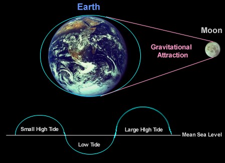
Tides are the alternate rising and falling of the water level in the ocean and big lakes caused by two forces:

· The gravity force of mostly the moon, but the suns gravity force also has an impact on the tides.

· The centrifugal force caused because the moon and the Earth in spinning around a common axis.

The two forces results in two tidal bulges on each side of the earth, which is almost equally big. The fact that we have to tidal bulges results in semi-diurnal tides, which mean that we mostly have two low tides and two hide tides in a day; but because of the landmasses on the earth, we sometimes only have on high tide and one low tide in a day. Another factor to remember is that the Earth has an inclination of 23.5degrees that results in mixed hides of the tides. There are other factors that can effect tides like; wind, large inputs of water from rain and rivers, atmospheric pressure and the coriolis effect.


Salinity and temp. at 21.30

Salinity: 30,5
Temp: 10,8

02:20 night data

The 02:20 data on friday night/saturday morning was as followed
Temp: 10,3 degrees
Salinity: 30,2

Saturday, April 17, 2010

12:32 data

I just measured temperature and salinity of the water at 12:32 (minimum tide)

Temperature: 11.1°C
Salinity: 30.4 ppm

The next measurement will be at 15:30 (Nile)
18:30 (Johan)
21:30 (Renata)

Salinity and Temperature At Differing Tides: A study of Pedder Bay


After many exhilarating meetings, the group has decided to conduct a study of temperature and salinity at the differing tides. This includes the values for the mentioned physical variables at high tides and low tides. This study seems to be dominantly concentrated in the Marine Science discipline and we were provided with sufficient background information in relation to this by on e of the group members; Sune. This study seems to be quite fascinating in that we very rarely wonder about the correlation tides and how they affect said variables. We know that there are different zones within Pedder bay, that of the mouth of the bay; where the bay meets the Pacific Ocean, the mid-interval; where the Pearson Docks are situated and the mud flats closer towards land. This in turn would imply that there might be varying temperature and salt concentrations in the different zones mentioned. As such, this study proposes to investigate the salinity and temperature of the mid-interval zone and compare with values obtained near race rocks.